Place names are some of the hardest things to transcribe (preaching to the choir here, I know!), which is why it’s critical you confirm the existence of a place name once you’re done transcribing.
All too often, you think you’ve transcribed something correctly, and then you realize no such place exists. Certain articles have already offered some really great resources for verifying places (see 7 Genealogy Hacks for Verifying Your Ancestor’s Hometown post). However, I don’t think you can ever have enough map resources, especially given how often place names and jurisdictions have changed over time. I’ve gathered up a few of my favorite (and perhaps lesser-known) resources that will hopefully help your research.
- Atlas des Deutschen Reichs (“Atlas of the German Empire“)
One of the most detailed map resources available online is the Atlas des Deutschen Reichs by Ludwig Ravenstein from 1883. It covers Germany and its bordering areas (i.e., Austria, Belgium, the Czech Republic, Denmark, France, Hungary, Lithuania, Luxembourg, the Netherlands, Poland, the Russian Federation, Slovakia, and Switzerland). The University of Wisconsin has the entire atlas digitized online (https://search.library.wisc.edu/digital/ARavenAtlas).
This resource is most helpful if you know the name of the village you’re trying to find or at least the name of one nearby. Since this is an atlas, you can also search by physical features (e.g., rivers, mountains, etc.), which can be helpful if you have a general idea of where a village is located vis-à-vis a natural landmark but are unsure of the specific name.
Your first step in using the atlas is searching for the place name. Let’s say you want to find Altenberg. You’ll enter the name in the search box, and it will return any instance of the place mentioned in the gazetteer section of the atlas.
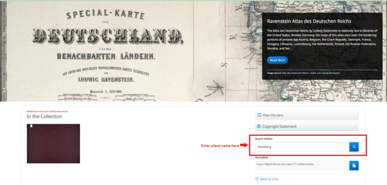
Image 1: Searching in Ravenstein Atlas
Click on the link to the match that appears within the atlas, and then zoom in.
Using our example town of “Altenberg,” we can see that we need to look at map IV, quadrant E5. Click on the link to the book title Atlas des deutschen Reichs (top left corner) to go back to the table of contents. Scroll down to find the appropriate map section – here “10. [Map Section IV] and click on that link.
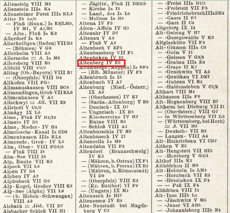
Image 2: Search Results in Ravenstein Atlas
You’ll notice that the original maps are pretty big when you go to the map section. So, when you actually want to look at a specific map, you should click on the magnifying glass. The letters describing where the town is (here: E) are in red at the top, and the numbers are in red on the left side of the page (here: 5 – Map IV, E5).
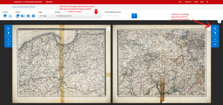
Image 3: Map View in Ravenstein Atlas
The other major benefit of using this atlas is if you are trying to discover the current name and/or jurisdiction of a town from a historical record. You can look for physical features on the map or the nearest major city and then compare it to a modern atlas to find the contemporary name.
According to the UW library page, the benefit of knowing the contemporary name/jurisdiction is that you can “use current government directories, genealogical handbooks or other reference tools to identify the appropriate governmental office, etc., for the genealogical records wanted.”
A few other notable features
Just like the Meyers Gazetteer, church locations are indicated on the map. What I especially love, though, is that the atlas gives you a better idea of the denominational makeup of the German empire. Section 18 of the atlas “Verteilung der Konfessionen in Deutschland nach den Ergebnissen der Volkszählung vom 1. Dez. 1880“ (“Distribution of Denominations in Germany According to the Results of the Dec. 1, 1880 Census”) shows a pretty obvious divide between the Protestant and Catholic parts of the German empire. The map provides statistics down to the Regierungsbezirk (administrative district) and Kreis (district) governmental units.
To understand this map, make sure you look at the key located on the bottom right.
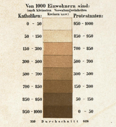
The English translation reads: “Out of 1,000 inhabitants, ___ are: (according to the smallest administrative units, districts, etc.).” The darker the color, the more Catholics there are; the lighter the color, the more Protestants there are.
The other section that I really like is Section 5, which offers a breakdown of the types of crops/production in each of the different provinces and lands in the German empire. Many records we deal with list farmer or landowner as the person’s occupation, but they don’t offer any insights into what type of crops these farmers had or what land they owned. While this chart cannot tell us what an individual farmer grew, it can provide insights into the types of crops and livestock common to a specific province/region. If a farmer lived in Baden, chances were pretty high that they had cattle and grew tobacco since the area used for these two things is significantly higher than anything else listed for Baden. The chart is in German but using DeepL, ChatGPT, or Google Translate should give you a good idea of what each category is.
Additional Maps
- A New and Comprehensive Gazetteer, Volume 2 by George Newenham Wright
This is a free downloadable gazetteer written in English and published in 1835. It is very extensive since it is not German-specific; instead, it is a gazetteer of the entire world. You can use the search bar on the left to find specific places.
While this isn’t a map resource, it can help you better understand individual entries on https://www.meyersgaz.org/ without having to open up your dictionary every time. It includes the full German name along with an English translation for the abbreviations used in Meyers.
Anyone working with records in the area of modern-day Poland knows how tricky it can be to find the contemporary name for a German place name. This list includes both the German and Polish name. Although this Wiki page does have an English version, I find the German one easier to navigate since it’s separated alphabetically.
This gazetteer and the maps and other resources on the website are invaluable for anyone working with records in the Volga region. The gazetteer offers multiple spellings (incl. in Cyrillic) of colonies and alternate names. There are also resources on resettlement locations for the German colonists as well.
I hope these map resources help you! Any other ones you would include? Let us know in the comments!
6 Responses
The University of Wisconsin Milwaukee library (Golda Meier library?) had (and I assume still has) the complete set of German maps used during WWI by the US Army. I was told it was the only one in existence. I used it some 25 years ago . The maps are incredibly detailed, showing forests, water, and even buildings.
Hi Nancy, Marisa here. What an amazing resource to be able to look at! Your comment led me to discover that UWM’s American Geographical Society Library has a huge digital map collection online, free to access, with over 20,000 maps available. I also had no idea the AGSL collection itself is nearly 2 million items and has been described as the second-largest map collection in North America, after the Library of Congress. What an incredible resource!
Marisa,
The Wright Gazetteer is not downloadable.
https://books.google.com/books?id=CCMDAAAAYAAJ&pg=PA596&lpg=PA596&dq=Deckingen+germany&source=bl&ots=Ste_zo-PFU&sig=Vn4KDk7B2qlyME5n6ygAWKwCO4o&hl=en&sa=X&ved=0ahUKEwj6i9qRqI_aAhVO6VMKHVNsAMMQ6AEIMjAC#v=onepage&q&f=false
Hi Sandi, Marisa here. I just checked on my end, and it looks like the Wright Gazetteer can still be downloaded with no issue. If you use the link in the article and open it in Google Books, you should see a gear icon in the upper-right corner—clicking it gives you the option to download the book as a PDF. It worked for me, so hopefully it does on your end as well!
Thanks, Marisa!
Thank you for the great resources.